Blog

There is a problem with renewables. They are meant to be cheaper than fossil fuels, but as we add more of them our electricity prices have been rising. This has led to some of our politicians claiming the price rises are due to renewables themselves, which seems to make some sense. Doubling up our electricity production so we have renewables for when it's sunny and/or windy and gas/nuclear for when it's not seems like it could be a more expensive option. So let's not worry about climate change and don't bother building any more renewables. Right?

Except that's not what's happening. With our current level of renewables, we are never turning off some of our gas powered stations. And electricity in the UK is priced at the level of the most expensive producer, so it is always tied to the price of gas. And the price of gas shot up after Russia's invasion of Ukraine and is still higher than it was previously.

But, perhaps reasonably, some people will be sceptical of this explanation until they see their electricity bills falling. So I thought I'd try to figure out when we should see gas falling out of our generation mix. I downloaded the historic data from NESO and did some simple analysis of it

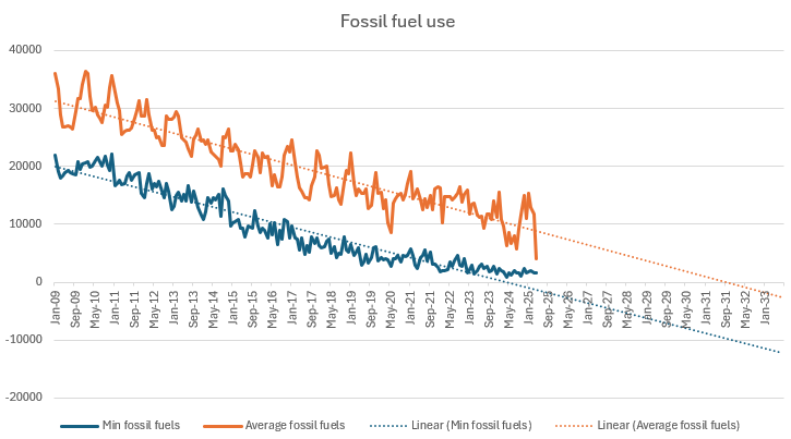
For every month, this shows the minimum and average usage of fossil fuels over a half hour period, both with a linear trendline, which mostly fits the data sets.

The first milestone we should hit is a period of 30 minutes where we don't use any fossil fuels. The linear trendline suggests we should have already hit that milestone, but the drop seems to have stalled over the last couple of years. Maybe someone with a better understanding of the National Grid can explain why that has happened, but it seems like something we'd want to happen as quickly as possible from the consumers' point of view. I think that possibly from the government's point of view it may not be something they'd like to happen too soon. From my understanding, renewables get a fixed price for their electricity, if the wholesale price goes below that price, the government pays the difference. 

The next milestone will be when the average fossil fuel usage gets to zero. That trendline is looking linear at the moment but I'd expect that to flatten as it approaches zero. In long periods of low wind and sun, storage is not going to be able to meet demand. So maybe it's better to look at renewable electricity production. 

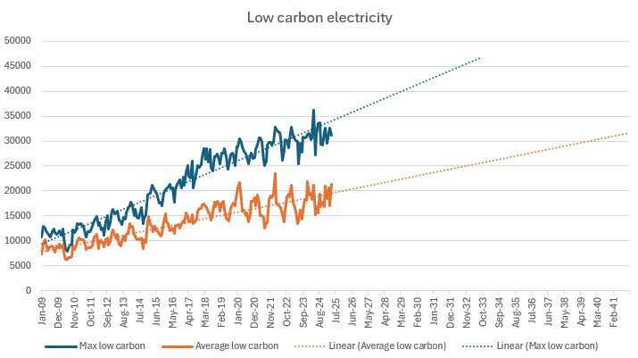
The NESO low carbon figures include nuclear, wind, solar, hydropower and biomass (eugh) and the maximum and average are displayed above. The UK typically requires about 30GW of electricity and the trendline suggests we'll reach that average level in about 2039. Then we'll be producing enough electricity by renewables to meet our needs but some of that will be getting exported when we are producing too much so we will probably still be using gas for some periods. My understanding is that is the definition the government is using for a green National Grid which they hope to reach by 2030, so our renewables output is really going to need to step up a few gears in the next few years to reach that goal.


Supported by National Energy SO Open Data

I've uploaded the latest house price data for England and Wales to the website. Prices continue to creep upwards and sales volumes continue to look fairly lacklustre. As I'm writing this, an orange man in the US has just started a trade war with the rest of the world, so who knows what will happen going forward

Somewhat belatedly I've uploaded the latest Land Registry data to the website. The annual price change is almost back in positive territory, although prices are still some way off their peak in the summer of 2023. Essentially prices have been stagnant for 2 years. Sales volumes still look pretty poor.

I've uploaded the latest ONS postcode date to the site. It all looks OK but let me know if you spot anything amiss

I've uploaded the latest data for English and Welsh property prices to the site. It looks like the current trajectory is flat-lining prices even though the annual change remains negative. Sales volumes continue to be low

Possible London boundaries

One of the more popular pages on the site is the postcodes in the City of London administrative area. This confused me for a while since the City of London is a small area that is important for financial services but not much else. I came to the conclusion that it was based on people trying to find a list of all London postcodes so I added a link to a more comprehensive page of London postcodes. But then I wondered if that was really what people would want from a list of London postcodes and where in fact London ends. So here's a brief description of what the options are.

The City of London administrative area does closely line up with what was considered London several hundred years ago. It's now more commonly known as the Square Mile and as you'd guess from the name, it's tiny. It's the smallest black area in the map above

This list of London postcodes is a list of postcodes that are considered to be in the London post town and consists of the E, EC, N, NW, SE, SW, W and WC postcode areas. I guess when those postcode areas were created, that may have been considered the extent of London, but I don't think anyone would think that now, Wembley Stadium and Heathrow Airport are both outside it. It's the red area in the map.

The larger black area above is the area covered by the Greater London Authority, which is probably what most people would consider as London these days. You can download data for this area here

But even that may not be enough. Maybe you think anything inside the M25 is London. Certainly London's urban sprawl now extends beyond the boundary of the GLA. I don't currently have data for this but it's on my To Do list. It's the blue area above.

But the urban sprawl extends beyond the M25 in places, so maybe that doesn't really define the boundary. What about the area where people mostly work in London? The London Travel to Work Area data is here and is shown above as the blue shaded area. That gives a completely different area than the others, with a big chunk taken out of the Western side by areas where people work in Slough and Heathrow, rather than London.

So to answer the original question, where does London end? It's not really clear. Sorry I've not been more helpful, but maybe it will help you decide which specific London data you should download

The latest data from the Land Registry is now available on the site. The annual change in prices is still negative but looks to be heading back to positive territory. Sales are still in the doldrums

A little late but I've just uploaded the latest postcode data to the site. The biggest change is that new built up areas (from 2024) are included in the data. 

I've run my usual sanity checks and not found any issues, but let me know if you find anything amiss

I've uploaded the latest house price data for England and Wales to the website. I've also added a map showing the average prices in the different postcode areas, which unsurprisingly highlights that London and the South East are the most expensive parts of the country

If you're a fan of British train stations (and who isn't?) then you'll be excited to learn I've uploaded the latest station usage data to the site. Liverpool Street in London retains its position as the busiest station, thanks to the extra traffic from the Elizabeth line. Overall usage still hasn't quite reached pre-Covid levels, presumably due to WFH becoming a bigger part of people's lives.

In other news, I'm on Bluesky, since it looks like it may remain a sane place dues to its ownership model. Follow me there if you want to read the same things you can read here

Tagged: Stations Website